
- You have no items in your shopping cart
- Subtotal: $0.00
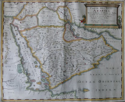
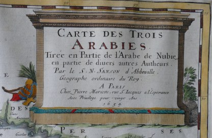
Title – Carte des Trois Arabies tirée en Partie de l’Arabie de Nubie en partie de divers autres Autheurs, par le S N Sanson d’Abbeville Géographe ordinaire du Roy… Published – Paris, c1667; map dated 1654 Description – Large antique copperplate engraving on watermarked paper with outline hand-colouring, in very good condition with clear margins, traces of a fold, but flat Dimensions – sheet 522x411mm, map 485x397mm A milestone in European mapmaking of Arabia prepared by Nicolas Sanson d’Abbeville (1600-1667), Geographer to Kings Louis XIII and XIV of France. The map incorporates knowledge from the Kitab nuzhat al-mushtaq fi’khtiraq al-‘afaq of Mohamed al-Idrisi (1100-1165), which was first printed in Arabic in Rome in 1592, and translated into French in 1619 as Geographia nubiensis. The three ancient Arabias of the title – Petraea, Deserta and Felix – are overlayed with a wealth of more contemporary information, with names of cities, regions and even tribes. Iraq is clearly identified. The Gulf is named as the Gulf of Basra (Balsera) or the Sea of al-Qatif (el-Cattif). Using al-Idrisi’s work means that this map includes much that had never been seen before in Europe. The Hijaz (Hagias) is shown in western Arabia, inhabited by Beduins; a mountain range is correctly shown running north from modern day Yemen to Najran and further north (though Najran is too far east in the map); Oman is named for the first time in a European map. The map also shows the territory of the Yazidis (Rahabat Malec ben Tauc), to the north of Arabia Deserta – Melek Taus is a central figure in Yazidi religion. There are still some inaccuracies. The Sinai peninsula is not separated from Arabia; a large lake is shown near Marib in Yemen (a memory of the ancient dam?); the peninsula of Qatar is missing. But Sanson’s map was a breakthrough, and the basis for European maps of Arabia for at least the next fifty years. This map is from an atlas, Cartes générals de toutes les parties du Monde, published by Pierre Mariette in Paris in 1667. The map is catalogue number 99 in Arabia in Early Maps by GR Tibbetts. The map can be seen as part of a later version of the atlas, dated 1694, at the online David Rumsey Map Collection – link below. https://www.davidrumsey.com/luna/servlet/s/793o8n
Q & A
There are no questions yet